John Vonderlin asks: Is this a good idea?
Story & Photos by John Vonderlin
Email John ([email protected])
Hi June,
Created by June Morrall
John Vonderlin asks: Is this a good idea?
Story & Photos by John Vonderlin
Email John ([email protected])
Hi June,

 Story & Photos by John Vonderlin
email John ([email protected])
Last week there was another of those weird wracks onshore at Invisible Beach. It’s marine debris load was dull, but there was several formerly living things in the seaweed I couldn’t remember seeing before.
I’ve attached a photo of one of the specimens, probably an algae.
I also attached a photo of another “squid” I found in the same wrack. It’s an ugly one with lots of odd things entangled.
At one point I had my collection of squids hanging all in a line on one wall of my redwood gazebo, calling it “The Wall of Shame.” Not even I, a great admirer of loathsome marine debris of all kinds, could not stand it after a while and had to pack it away. Enjoy. John
 Story & photos by John Vonderlin
Email John ([email protected])
Hi June,
Some time ago I posted a story*** about what I consider the most viewed Sea Arch on the San Mateo coast.
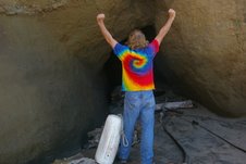
I maintained that this arch was the one on the promontory that forms the southern bank of Pescadero Creek where it flows into the ocean. There was some mention by someone that the arch was actually “a hand dug tunnel.” Curious, I went to look for myself, checked it out, took a lot of photographs and opined that it wasn’t regular enough to be manmade.
Besides why would somebody go to the trouble of digging a seemingly pointless tunnel?
Well, last week I was showing my neighbor the California Coastal Records Project (CCRP) website. I was demonstrating the Time Comparison feature when he commented that he and his high school buddies used to party at the beach pictured on the screen. They knew it as “Hole in the Wall Beach.”
That Hole in the Wall is none other then the sea arch opening? tunnel? at Pescadero Beach. Only my neighbor informed me that he was sure it was a tunnel because in the Seventies the sides were much more regular, demonstrating its manmade origin.
While I’m not one to question the hazy, thirty five- year- old memories of a drunken youth, I was still having trouble wrapping my mind around the idea of somebody going to the trouble of digging a tunnel in that spot.
A few days ago while reading the transcript of a “Pescadero Oral History Project” interview with Ron Duarte, the owner of historic Duarte’s in Pescadero, I got my answer. Sort of.
“A bunch of old timers made that tunnel,” said Ron. “ It is not natural. Everybody thinks it is natural but it is not. They thought that was going to keep the mouth of the creek open. Maybe it did and maybe it didn’t. But, most of the time I don’t think it did much good. That was man-made, that tunnel.”
In another interview, also on the Pescadero Oral History CD, Marty McCormick was asked the same question.
Interviewer: Do you remember the tunnel at the mouth of the creek?
Marty McCormick: Out by the beach. Oh, yeah. It is still there. We used to crawl through there. There were some years where it was totally filled in with rock and then there were other years when you could go through there without having to do a belly crawl. I have pictures of my kids inside when they were pretty young—twenty-five, thirty years ago.
They’ve convinced me. It’s a tunnel. The battering surf has naturalized the opening over the decades. And while, to me, it seems obvious that a tunnel is as likely to sand up as the creek mouth itself, somebody, a long time ago, thought excavating one was a good enough idea to invest a lot of hard work. At least they’ve left us a durable monument to the futility of trying to make Mother Nature do our bidding.
I guess it’s also Sea Arches Minus 1, Beach Tunnels Plus One and Oldtimers 1, Young Whippersnapper 0. Enjoy. John
***
Hi June,
This was the main posting I did about what I thought was a Sea Arch at Pescadero Beach. I’m going to revisit it and see if there is any sign still left of its manmade origin. Enjoy. John
Re: Pescadero’s Pride & Joy
Hi June,
I think of all the Sea Arches on the San Mateo coast, the one just south of Pescadero Creek, is the most well-known and one of the most photogenic. It is visible from the Highway 1 bridge that crosses the creek and easily accessible by pulling into the most northerly parking lot of Pescadero Beach. It is not that difficult to climb down and walk through it, provided the creek is not raging and there is a reasonably low tide. If you are not handy jumping from rock to rock you should be ready to get your feet wet. Looking at the 1972 pictures of this arch on California Coastal Records Project (CCRP), my guess is that unlike many other sea arches on our coast, it will be there a long time. Picture #6257 on CCRP gives a nice overview of this area, helping put the pictures I’ve attached in better perspective. Please note that that Picture #6257 was taken in September before the winter rains which open the creek to the ocean and remove much of the visible sand. Enjoy. John
Special thanks to John Vonderlin ([email protected]) for the following post.
From: Coast Dairies Property: A Land Use History, click here
“The Davenport cement plant (it became Pacific Cement and Aggregates in 1956, Lonestar Cement Corporation in 1965 and RMC Pacific Materials in 1988), brought immediate military attention to the North Coast following the attack on Pearl Harbor in December 1941. Believing that Japan might attack the U.S. mainland, the military quickly posted guards and lookouts around Davenport and imposed stringent blackout requirements on its residents.
“Later in December, when the ship Agiworld was attacked by a Japanese submarine off Cypress Point south of Monterey, security along the coast was heightened. A Japanese submarine was also sighted off the coast a few miles north of Davenport, resulting in a brief skirmish between the submarine and a single plane from the Army Air Corps.
“Eventually a segment of the all-black 54th Coast Artillery was stationed at Davenport and regular night canine patrols were instituted at all the area beaches. In addition, four shore mounted guns were placed strategically around the Cement Plant. Two 75mm guns were mounted overlooking the pier and two 155mm Howitzers were mounted just to the east of Newtown. Many of the young people living in the area at the time became airplane spotters, spending long hours in the lookout stations posted along the coastal hills.”
I look at many historical photos of the Coastside, including the beautiful beaches. After awhile I can’t help but notice that the beaches have changed dramatically. Most of us have no idea how much bigger the beach at El Granada was in the 1920s, or how many rock arches and caves were once part of the scenery at Moss Beach. Sand dunes covered Miramar Beach and there were nice little beaches at Princeton, too.
When did the change begin? The photos seem to say it began in the late 1920s, 1930s. That made me wonder about the Golden Gate Bridge. The bridge was built in the late 1930s. Could it have had something to do with the loss of sand on the San Mateo coastline?
John Vonderlin spends a lot of time exploring the remote South Coast beaches, many of them inaccessible, taking photographs, revering and studying the beauty that he finds.
I asked John, could construction of the Golden Gate Bridge have affected the San Mateo County beaches?
John said: I’m no expert, but here’s what I think is going on with the sand disappearing from our local beaches. First, I don’t think the Golden Gate Bridge has had a significant effect on our beaches. The tower foundations aren’t big enough to interfere seriously with the transport of sediment out of the Bay and possibly into the littoral cell south of the Golden Gate Channel.
This is from a USGS site, click here
Whatever part of that sediment that gets swept up in the Longshore current, along with the sand brought down by our local creeks or eroded from the many local wave-battered sandstone cliffs, ends up feeding and sustaining our beaches.
Dams were probably the biggest factor in the disappearance of beaches, perhaps not here so much as other places. The impoundment of sediment behind the dam on the bottoms of gradually growing more shallow lakes and ponds, surely has had an effect hereabouts. But I don’t think they are the main factor. After all, I don’t know of any new local ones being built in a long time, yet the beaches have seriously diminished using the 1972 California Coastal Records Project’s photos as a comparison. In fact, the general trend has been to remove dams in the various coastal watersheds to re-open ther streams for fish migration. Likewise, the friable, easily eroded, sandstone cliffs that contribute so much raw material to our beaches haven’t significantly changed in that timespan.
There is one plausible reason the sediment load carried to the sea from our local watersheds has greatly diminished. And that is environmentalism. Logging has greatly diminished and been forcefully required to improve the watershed protection techniques they employ. Farming is in a similar position as logging is, both as a shrinking business and one that has learned or been required to practice better land stewardship. Based on some of the pictures I’ve taken of turbid runoff entering the ocean from irrigated coastal fields, there is still more that needs to be done.
All in all, erosion control has greatly expanded in almost every aspect of land use in the county, from road building, home construction, and land clearing, to runoff management protocols and wetland restoration or protection projects.
We’re being skewered by our own success. If we prevent sediment from getting in the water flowing to the ocean we can’t expect much in the way of beaches. Unfortunately, I think it is a classic Hobbesian choice situation( i.e. your money or your life) where the Golden Age of San Mateo beaches has come and gone and there’s not much we should do about bringing it back. Enjoy. John
The Wrack is Back
Story & Photos by John Vonderlin
Email John ([email protected])
The wrack is back. Actually it’s been back since April 1st. After the April Fool’s trip to the tunnel that isn’t there, and the sea arch that was, we decided to do one of our regular Invisible Beach checks.
We didn’t have any expectations as there hasn’t been any action from Neptune’s Vomitorium in about six months, and the ocean was as calm and wave-free as I’ve seen since last fall.
Surprise! A substantial pile-up of fresh wrack was on the beach above Neptune’s Vomitorium
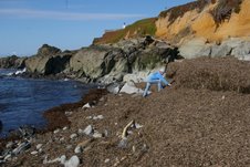
with more stuff coming ashore.
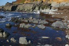
Greedily gathering every treasure visible in the huge pile, we filled a very large bag. Taking it home I sorted, photographed, washed and stored away our bounty for future use. This first “cream of the crop” selection was definitely “high grade” as we say in the Marine Debris world.


I’ve returned three more times in the ensuing weeks and captured the debris released by the disintegration and decay of the wrack. Each time, I gathered a substantial, but decreasing, quantity of “lower” grade debris. It looks like the “lastawrack” time will happen soon, and we’ll have to be patient until this natural wonder visits once again. Enjoy. John
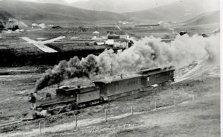 (Photo: Is this the Ocean Shore Railroad smokin’ through Pacifica?)
Mr. Vonderlin, I’ve enjoyed reading Half Moon Bay Memories and El Granada Observer as well as your Pescadero Memories, particularly references to the OSRR, which I became acquainted with in the late 1920s.
My uncle took my brother and me on a hike along the right-of-way from Thornton to Mussel Rock. Though the rails had been torn up, still it was obvious a railroad had been there.
In 1939 I made several bike trips down the coast from San Francisco, once climbing to the top of the collapsed tunnel at Pedro Point to view the grade south to Devil’s Slide. And I also drove to Santa Cruz in a friend’s Model A Ford, borrowed from his brother, always looking for OSRR remnants.
At Pescadero beach it looked like grading of the dunes had been done south of the “mysterious tunnel” bluff you described. On a much later visit I found the tunnel portal, and since the grading I’d seen earlier would have led to the tunnel site, I surmised that the OSRR had built the tunnel either as a pilot bore, or to use it to blow down the hillside for easier grading.
Your north portal pictures puzzle me as they don’t appear to coincide with this surmise. I’ve never seen anything about this in the OSRR literature.
Re the Palmer Gulch Trestle: I have a photo of it given to me in 1939 that shows the trestle had already started to sag in the middle. About 1960 a friend and I hiked down to it; by then it was sagging noticeably. On the north side was a large, weathered (tool?) box, about 12’x4’x4′ roughly. It had an old padlock on it which we left as is.
We walked across the trestle, and my friend took pictures, of which I have a couple. Unfortunately, they are now badly faded (Polaroid camera?). but the rotted ties are still evident. I don’t believe it burned down because I saw an internet picture of it taken a few years after our crossing, and it was in nearly collapsed condition, and the text said it totally collapsed shortly after. Regrettably I didn’t add it to my OSRR “favorites,” and have never found it on the Web again.
Thanks again for your interesting memories of the San Mateo coastside.
Angelo Misthos, Sebastopol CA.
————————————–
John Vonderlin replies
(email John: [email protected])
Hi June,
I received this interesting email today. It reminded me the tunnel (s) story is not a mystery solved. I’ll get back to it. The gentleman from the cemetery has said he’ll show us it, so maybe it exists. I sent Angelo a picture of a burnt timber, though that might have happened after collapse. I loved that he lives in Sebastopol. I used to have a wonderful ranch/family orchard in the hills west of town during the Seventies. George Lichty, the cartoonist of “Grin and Bear It,” fame lived across the street. The Thomases who owned the American Opinion Bookstore (John Birch Society–remember them?) were at one corner, two gay interior designers from S.F. on another and a schoolteacher couple who were Sufis on another. A great time in my life to recall. Where has my youth gone?
Larry Fitterer and I are going to be lowering ourselves down the cliffs into “The Notch” and Acid Beach on April 9th or 10th. Yee-Haw. Hopefully, I won’t break my typing fingers or anything else. Enjoy. John
To read John Vonderlin’s piece on Purissima Falls, click here