Driving to Devil’s Slide
[youtube=http://www.youtube.com/watch?v=clbRKyIkaOE]
“Mad As Hell” Emails
Dear June Morrall,
As a Coastside commuter for the past 20 years, I have an interesting observation for you: One of the important things every commuter does is listen attentively to the radio traffic reports on AM 740 or AM 810.
They provide valuable information. Sometimes the Bay Bridge toll plaza is overloaded. Usually the San Mateo-Hayward Bridge is a big problem. Those are chronic situations but never ever before has a constant traffic problem been totally ignored by these traffic reporters.
They no longer talk about 92 and Devilâs Slide. Occasionally thereâs mention on the general news usually telling us the date for reopening Devil’s Slide is even further out. When it comes to the Coastsider’s twice daily commute agony, it’s as if everybody else in the Bay Area has suffered amnesia.
Keep up the good work, June.
From: âIâm also mad as hellâ?
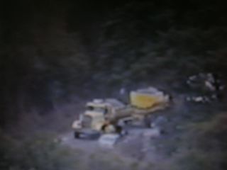
June: I just got home and I followed two garbage trucks that turned from Crystal Springs onto 92. It was slow going all the way, until they turned into the dump, then it was smooth sailing into town. This happened at twenty minutes of 4. Whatever business they had at the dump, they could have done it after 7 p.m.
Montara Bob
“Mad As Hell And I’m Not Going To Take It Anymore”
The garbage dump used to be near the beach in the early 1970s. The passage of time has blurred the location but it was down a dusty road near the beach. And there stood a funky wood shack where a tall, skinny guy took money for dumping “stuff”. I recall there was a giant white golf ball that marked the spot.
You wouldn’t think going to the dump could be fun but this WAS fun. (Being a City girl, I’d never been to a dump before but the guy in the shack and the golf ball, well, together they were academy award winners).
Today–as we drivers all know only too well– because we see the garbage trucks everyday– they’re either in front or in back of us heading for a once unspoiled canyon off Hwy 92– that’s where the garbage is dumped today.
I was there once or twice–I didn’t want to come back– there were many screeching seagulls, and all that accompanies that– no trees, and it wasn’t memorable–except that I still wonder why anyone in a responsible position would sign a contract to make this remote location off a busy two- lane country road the dump for most or some of San Mateo County.
Maybe we should revisit that contract again.
Since 1970 the Coastside has grown and grown and grown. The dump is located off Hwy 92, a very busy road– and today the only road for hardworking Coastsiders to get to their jobs on the Peninsula. Oh, you could take Hwy 1 south and then go east to reach the Peninsula—but the roads going east are not much more than quaint wagon trails–I’m exaggerating but not by much. (Of course, the reason the roads south of Half Moon Bay are “crude” is because (1) not many people live there and (2) the roads going east take you to the wealthy suburb of Woodside and in this horsey town with no sidewalks, I would bet the residents don’t want to see Coastside commuters.)
I am absolutely not lobbying for more Coastside roads or for widening the existing roads, such as they are. We don’t want a dump near the beach, either. And, obviously we need garbage trucks–their drivers and workers are hardworking folks, too, I know.
But common sense tells me that until Devil’s Slide is reopened, the commuter is the victim and he/she should have the right-of-way on Hwy 92. Perhaps garbage trucks should– during this temporary emergency (meaning until the old Devil’s Slide roadway is reopened)– use Hwy 92 during off-commuter hours– even late in the evening.
Even before the Slide was closed, it was difficult for the garbage truck drivers to negotiate their way over Hwy 92–the trucks are big, sometimes stuff flies out of the truck bed–they really need the entire lane, commuters and drivers can’t pass them easily–and when the trucks get close to the official “dump” they clog up the road, hugging the shoulder but still significantly slowing down commuter traffic. At one point I even saw the Californa Highway Patrol directing traffic on the road outside the dump because of the extreme congestion–and that was about a mile from the town of Half Moon Bay.
Please email me, give me your ideas for alleviating traffic on Hwy 92 and I’ll post them. Thank you for the emails I’ve already received.
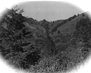
If you love the Coastside and you love nature, you’ll weep when you see this “before” image of Ox Mountain, today the garbage dump for most of the county. The use of Ox Mountain as a garbage dump has produced a scar that can be seen from miles around. We must ask again, why on earth would a responsible person make a deal for a garbage dump to be located on a two-lane country road?
P.S. We LOVE carpools and commend all those who organized and participate in the program.
Where We Live: The Edge Of The Known World
You know, when you turn onto Hwy1 from 92, going north, and you pass through the light and then there’s the big green sign that tells you how far away El Granada, Montara, Pacifica and San Francisco is? Since the Slide has been closed–our sole north-south connection–Caltrans covered Pacifica and San Francisco with a jagged piece of brown cardboard paper. For Coastsiders, they don’t exist.
You can’t get to Pacifica or the City. Lovely Montara, founded as an “Artist’s Colony” is the last stop before the turnaround.
A few days ago I was so amused to see that a very creative “someone” had written in lovely print above Montara these words: “the edge of the known world”.
How right that clever someone is. Look for it.
“Mad As Hell And I’m Not Going To Take It Anymore”
Today, Tuesday, I was driving back to Half Moon Bay on Highway 92 at 1 p.m. when it became clear that something bad had happened. (The all too familiar signs: No visible traffic heading east and traffic heading west was stopped.)
Obnoxious delays on Highway 92 are almost a daily occurrence– but wouldnât it have helped me, the commuter, the driver, to see a sign along the road advising me what had happened and how long it would take to clear up. Especially during this very difficult time when Devil’s Slide is closed and the entire Coastside is dependent on one little road.
âAccident, Tow Truck, Road Closed, Minor Injury, Serious Injury Accidentâ?âimportant, possibly life-saving words that alert me the driver so that I can make a rational decision based on valid, current information. A decision to proceed, turn back, make a call to my loved ones, that kind of a decision.
(Occasionally, I’ve seen a sign lit up on the San Mateo side of Highway 92–but not lately)
And no signs today.
Thankfully, the delay wasnât due to a major accident. I âthinkâ? a car died and was dragged to the side of the road. I say âI thinkâ? only because I saw a car and a tow truck pulled off to the side.
It was much worse last Saturday when Highway 92 was temporarily closed for several hours–and a sign alerting me of the accident (on the Half Moon Bay side) would have caused me to turn around before I ended up locked into a knot of traffic half way up the mountain which eventually caused my engine to overheat.
Had I known a mile earlier, I would have had the option of turning around, and I would have returned homeâor decided to sweat it out in the line. At least Iâd know what had happened and Iâd have options.
But I had no options and there was no sign alerting me of what lay ahead. I didnât know the severity of the problem until I turned on the radio and was told an oil tanker flipped over on 92. An oil tanker tipping over is a very scary thing. For me, the driver, being unable to move forward, backward or sideways while knowing that an oil tanker is lying on its side not far from me (ready to explode?) strikes fear in my heart.
You see, half way up that mountain you can’t turn around–there’s a concrete barrier in the middle of the road. You’re stuck. God forbid, if there’s a raging Coastside-Oakland Hills type fire (how will county fire trucks get to us using only one congested road?) or an earthquake?
Of course, it turned out that the radio news report was wrong. But I didnât know that for another hour, when I moved the fifty car lengths and reached the top of the mountain where a friendly California Highway Patrolman set me straight; itâs a water truck, he said, not an oil tanker.
Iâm calling for signs on Highway 92, alerting the commuter, the driver, the visitor, what has happened when there are delays and how long the delays are expected to last.
A Little More Travel Writing About The Slide & Other Tidbits (Part II)
In the 1930s, after the Ocean Shore Railroad gave up, and its rails were pulled up– the Devil’s Slide section of roadway opened following its construction by the old Joint Highway District 9 (San Francisco, San Mateo and Santa Cruz). The highway closely followed the abandoned Ocean Shore right-of-way.
Within a year, according to news reports, Devil’s Slide had suffered serious erosion and was closed for repairs after a heavy rainstorm. “Road Closed” signs became a common sight.
“The road,” wrote Aubrey Drury in 1933, “skirts Montara Mountain, with lofty Point San Pedro extending out west, its varicolored strata atilt; and as you round the point you command splendid vistas up the coast, along the dazzling white surf line of the Pacific. Point Reyes, Mount Tamalpais, and the Farallones are all in sight; and to southward stands the square tower lighthouse on Montara Point, while beyond glitters Half Moon Bay….”
This stretch of road could take one’s breath away. Sadly, it also struck a dark chord for people who wanted to end their lives and many succeeded. Later, an ordinance was passed in December, 1949, making it a crime to trespass on Devil’s Slide, or to park in certain unauthorized areas. This law also sought to bar amateur photographers from tumbling to sure death down the slide.
During the Second World War, there was a significant military presence on the Coastside–as the U.S. government built gun emplacements for five-inch guns in the Devil’s Slide area.
In the late 1960s the CEO of a Texas oil company was poring over aerial photos of the California coastline, seeking a spectacular new home site. He settled on Gray Whale Cove, where the California gray whale comes to spawn. The property originally belonged to the U.S. government and was used during the Second World War as an artillery observation point and had some light gun emplacements. Remnants of these structures remained on the property.
The business executive chose this particular piece of land “due to its beautiful setting, unusual climate, proximity to Gray Whale Cove State Park, and general secluded area being only eighteen miles south of the metropolitan San Francisco area.”
An architect was commissioned to design the new home. The plan included leveling the property near the top, requiring moving 94,000 cubic yards of dirt to allow for a yard around the house and an ample parking area. The design for the elaborate estate also encompassed the old fortress and a basement of about 24,000 feet. A stone facade and embattlements were to be added.
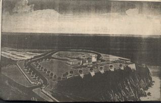
If this dream had been fulfilled–which it was not– the extensive plan would have changed the face of the Coastside’s sole north-south link. The primitive beauty of Devil’s Slide remains untouched.
Page Turner: Turning Angel

I’d never read Greg Iles before but his latest, Turning Angel, has me riveted. Entertaining and a real page turner. Iles is a thoughtful, compelling writer who does a great job of dangling several murder suspects before the reader’s eyes– and he shocks some of us with his knowledge about the behavior of today’s teenagers. In the “deep” of the book, the author tells us about the “turning angel”, featured on the cover. The book’s location in Natchez, Miss. takes the reader to a place far from Northern California.
Travel Writers Wrote About Devil’s Slide (Part I)
The spectacular Devil’s Slide slice of Highway 1, the Coastside’s sole north-south roadway link opened about 1933, shortly after Prohibition was repealed. This dramatic site where the mountains clash with the Pacific, has served as the backdrop for famous explorers, the failure of a railroad and wild shootouts between bootleggers and rumrunners.
Travel writers from the world over have grappled with words to describe the raw beauty before them. Now, as in the 19th & 20th centuries, this savage terrain has even defied the dreams of architects who sought to create lavish homesites.
Going back in time to October, 1869, the weary Spanish explorer Gaspar de Portola cast his eyes in the direction of Devil’s Slide (although it was nameless then) when he rested at the beautiful Martini creek campsite– one mile north of the Montara lighthouse on a dirt road east of the highway at the foot of the mountains.
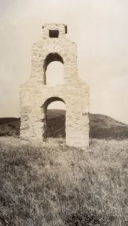
San Francisco publisher and Montara Realty President Harr Wagner erected a monument to Portola on Montara Mountain after San Francisco celebrated the Portola Festival in 1909. A photo of the monument appears in the 1918 edition of “Pacific History Stories”, written by Harr Wagner.

Photo: Monument erected by Harr Wagner
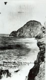
In 1892 a US Geological Survey map identified Devil’s Slide as a jagged rock formation running down the face of the sea. An even earlier map, dated 1881, indicated it might have been called “Striped Rock” because of the streaked (and very beautiful) strata.
J. Smeaton Chase, the author of “California Coast Trails,” (1913) rode his horse from Mexico to Oregon, passing through El Granada, the failed Ocean Shore Railroad resort. He noted the “…pitiful little cement sidewalks, already bulging and broken…”
Riding further north, Chase added, “…the road came again to the shore at Montara Point, where there is a small lighthouse. A mile ahead a fine mountain came sharply to the sea, and I could trace a road graded steeply over it…”
After covering so much flat terrain by the sea he didn’t expect to run into the geographical surprise, “…and I rejoiced at the sight. We soon began the climb, which brought magnificent views of cliff and sea, often several hundred feet almost sheer below.”
The road Chase encountered must have been the squiggly Pedro Mountain Road, the road which tightly and steeply wound its way to the crest. It lay east of the railroad tracks which clung to the cliffs and offered passengers thrilling views of ever-changing sea below.
When Chase was galloping over the mountain, the Ocean Shore Railroad was occupied with maintaining land that kept slipping into the ocean, interrupting schedules that drained the company’s limited reserves. Eventually, Devil’s Slide became a primary factor in the railroad’s declaration of bankruptcy.
During the heady days of Prohibition, the Pedro Mountain Road was the scene of shootouts and hijackings. Steaming, overheated automobiles became a common sight.
…to be continued..
“I’m Mad As Hell And I’m Not Going To Take It Anymore”
Today turned into an awful day.
We decided to take a ride to Berkeleyâwe would have taken Highway 1 north but with the Slide a broken link in the road, we had no choice but to drive over Highway 92.
It was going so smoothly, hardly any traffic heading east and I was smiling when I said to Burt, âLook, no cars in the other lane.â? There werenât. There werenât any cars.
And then, I burst out, âThere must be an accident. Theyâre holding the traffic back.â?
I only said that because there were no cars coming west. And then we saw a few, you know, as if something bad had happened and the cops were flagging a few cars through at a time.
We figured it was minor, nothing that would wreck our day. We kept driving (remember the traffic was light going in our direction) and we were so happy planning our day until going we were going uphill, and opposite Lombardiâs (closed) Springâit was then and there that we locked into heavy traffic that wasnât moving. Two lanes– standing still– on the hill.
We switched on the radio to traffic & weather togetherâand the first story was about the accident on 92. The reporter said an âoil tankerâ? has turned over on the highway and was blocking both lanes. The road was closed to traffic heading east, which meant us.
Maybe an hour later we reached the top of the hill, very concerned because our car was overheating. At Highway 35, or what I call Skyline, the cops had us turning right. They wouldnât let us go any further east on 92.
People were pulling into the rest stop, double-parked, and a lot of them were looking down the mountain at the accident. We pulled in, too, to check out our engine and canceled our plans to visit Berkeley. After a kind stranger from Pacifica poured coolant in our engine, and reassured us that our car was going to be okay, we took 35 to Kings Mountain Road and on to Woodside.
While at the rest stop, I talked to a cop directing traffic and asked him if an oil tanker had turned over. âNah,â? he said, âit was a water truck.â?
Thereâs the media for you. The thought of an oil tanker turned over kind of scared me.
Our day was ruined but in the grand scope of things, as Iâve said before, that wasnât too bad. Just a couple of hours wasted waiting on the road because thereâs no alternate route.
What does worry me is this: These days the Coastsider has become complacent, infinitely patient. Nothing bothers the Coastsider, Nothing upsets the Coastsider. Nothing phases the Coastsider. He/she has become indifferent to everything.
You know what Iâm talking about.
This time I just canât understand how the Coastsider can remain so indifferent about relying on one road while the other is undergoing repairs that they estimate will take four months, in time for Pumpkin Festival, which Iâve mentioned before.
Where are the people who are âmad as hell and not going to take it anymore?â?
I have lived on the Coastside for 35 years. I have owned a home for more than 30 years and pay taxes. I have written about the Coastside for 30 yearsâbecause I love Half Moon Bay, I love Ano Nuevo, Pescadero, San Gregorio, El Granada, Princeton, Moss Beach and Montara with all my heart. I have devoted thousands of hours researching Coastside history, collecting photos and writing about the history….
I cannot remember when both Devilâs Slide and Highway 92 were closed. Today it happened. Devilâs Slide was closed and Highway 92 was temporarily closed. I wasnât scared but I sensed âa where do we go nowâ? feeling at the top of Highway 35âthere were folks, young people, who didnât know the area.
Can you imagine, God forbid, what kind of chaos we would face if something really serious happens within the next four months?
Where are our real Coastsider leaders?