Time-wise, I am three hours behind, and one DAY ahead of the clock in Half Moon Bay. I just took my shower in the motor park where I spent the night sleeping in Paula’s van. Yesterday we went to the Warehouse, a discounter located in the “Remarkables” shopping center, to buy one sheet and a duvet for my bed. The van is a tight fit but it works. A narrow bench, upholstered in a vibrant red material pulls out to become a “bed,” which although it does not have a soft surface, put me right to sleep. We are parked near the kitchen which is outfitted with a stainless steel cook top, big screen tv, and internet hook-up. The “bathrooms” with shower are individual little buildings, three of them, with more in the main building–but not all the motor parks are going to be this comfortable.
We had a delightful lunch yesterday at Paula’s favorite place called “the Grind” in the industrial area of Queenstown.
We cannot escape “the Remarkables” but there are mountains everywhere, the kind that loom and let you know how small you really are.
Paula reminds me that we are sitting on an island in the middle of nowhere, subject to the whims of weather. Right now it is a bit sunny with some wind. She says wind is common this time of year. The weather is constantly changing and she says when it stays the same for a couple of hours it’s the big top of conversation here.
Paula Martin, my companion and guide, is a silver jewelry designer and native New Zealander. This is the time of year when she makes her pre-Christmas jewelry sales by driving through the South Island visiting shops and setting up at fetes, in this case one at a very remote location, which we are going to do later this week.
Last evening we sat in the van and sipped some bubbly as she pulled out her well worn (and beloved) maps of New Zealand, telling me stories about all the entirely original places she knows so well. She described birds to me with voices that chime, glaciers that move, and the terrain which you have to experience first hand to understand.
My friend, Paula Martin, the silver jewelry designer, met me at the Queenstown, NZ airport this morning. We got in her van and we were off on an adventure that will entail visiting fairs on the South Island where she will sell her work for the Christmas season–and, of course, we will be fully enjoying the local scenery. For now we are in Queenstown; I’m working on writing projects while Paula is organizing her jewelry.
Flying into Queenstown was an incomparable visual experience—you wouldn’t believe it—we flew in inbetween the mountains, low, and with the mountains on either side. All the water forms here, the lakes, are an intense azure blue, the blue you might find in the artist’s paintbox, or in your imagination. No gray-blue like the Pacific Ocean.
Overlooking the airport and Queenstown are “the Remarkables,” a set of mountains, tall and pointed. They can be seen from almost everywhere and overlook the shopping center with the same name.
One of Sir Walter Scott’s, most famous quotations is, “Oh. What a tangled web we weave, when first we practice to deceive.” Well, thanks to a bit of serendipity and our carefully nurtured cynicism, I believe we’ve discovered a situation that exemplifies the quotation’s message, a situation that might best be described by a similar-themed Scottish word, “skulduggery.” Somebody actually tried to carry out the deception of producing natural sea glass “gems” by finding an isolated and difficult-to-reach cove along the Coastside, and dumping a large collection of glass chunks, many of rare colors and types, into the gravel there, hoping for time and tide to give them an “authentic” surf-created polish, so prized by sea glass collectors. Well, they got lucky. because I found the scene of their crime, forthwith named Skulduggery Cove, and cleaned it up for them. While I don’t know the details of the law, I’m guessing dumping sharp pieces of glass into the Monterey Bay Marine Sanctuary, and thereby on a San Mateo County beach, for profit, is probably a big No! No! Now, I may be wrong about the “profit” part, and this is just an obsessed, misguided collector/artist, doing this. But, the circumstantial evidence says otherwise as I’ll outline in a future posting. As you remember, I posted briefly a few weeks ago about having the greatest sea glass collecting event in my life. Yet, I believed it might be a case of having to look a gift horse in the mouth and yell foul. That instead of having stumbled on a King Tut-ish trove of sea glass, I had stumbled on a counterfeiting operation. The PhD of a hoaxster graduate of the “Piltdown Man School of Shenanigans.” Well, having returned to the scene of the crime twice more, each time collecting a wonderful, if diminishing, assortment, of colorful glass chunks, I now have a more nuanced view of the whole enterprise. But, that might be because I’ve now collected enough sea glass to fill a large glass container, with which I’ll create a piece of artplay. I’ll be calling the piece, “Chicanery Glass.” I’m also expecting to enjoy myself writing a series of postings about this delicious subterfuge and all the subtle flavors wafting from it. Here’s an excerpt from my description of how this came to light on my first trip: …….Such was the case Monday, though the low tide was only a minus -.5. Picking out one of the difficult to reach, except during a good low tide, stretches of our coastside beaches, we soon were exploring. This particular stretch, south of Pigeon Point, has been our most reliable and prolific producer of abalone shells, including many complete ones. And though we don’t collect them, it’s fun to gather them and pass them on to a local artist for use in his creations. We weren’t finding many, which wasn’t surprising, as others surely had combed this stretch since the big storms of last winter. Still, I had my “Search and Find” circuits alert for small, easy to miss, yet attractively polished pieces. Hiking south we had carefully worked our way over the slimy rocks jutting from the end of a point and into a small pocket cove, I was delighted to see two pieces of cobalt blue sea glass, one of the rarer colors, nestled in the pebbles. Excitedly looking about, I found another, and another, then a piece of an unusual color of green, and then more blue. So it went, dozens of pieces of blue, interspersed with other unusual colors, with just a few of the common clear, brown or green found in so many beer or soda bottles. I was just thinking how this was the best collecting I’d ever done when “Eureka,” I spied a nickel-sized piece of red glass. I had never before found even one piece of this very rare color. Admiring it for just a second as I turned it over in my hand, I quickly cast my focus about my feet again and saw another. “Let me die now cuz it don’t get better then this,” I’m thinking. How wrong I was. As I moved up the beach to the base of the cliff I continued finding a rainbow of colors, along with a number of larger pieces, some that I quickly identified as parts of glass insulators, popular collector’s items themselves. Sea glass collector books opine that larger pieces, through some dynamic of the waves, tend to end up higher on the beach. This was the case here as the gravel at the cliffbase was smothered with a heaping helping of tasty specimens. I should mention. I’m not actually a sea glass collector. I do have a sea glass collectiom that fills several ornate clear vases, but it’s just another exhibition of a variety of non-buoyant marine debris, rather then a collector’s pride and joy. While I do admire the gemlike, polished contours of “Mermaid’s Tears,” the general lack of a history of dumping glass into the ocean along the southern Coastside, makes for slim pickings locally. That’s especially true for any color that didn’t originate from a beer bottle. This just was not the circumstance that generated much collecting enthusiasm in me. At some point, as I kept mining this bonanzic Mother Lode of treasure, where there should be none, cynicism crept in. Why had we seen none of this in any previous hikes through this cove? How could the majority of the pieces be of the rarer colors? And how come some of the pieces are sharp and fresh looking, while others are highly polished? I’ve been presented with a veritable enigma-stuffed conundrum slathered with a secret mystery sauce. Assuming deceit, why had somebody gone to all the trouble? When did they start? What were the pieces of unusual glass from? Where had they been acquired? Were there preliminary steps before leaving them at the beach? Who does this deceit offend or hurt? What is its value? I’ll try to answer these questions in Part 2 of “Chicanery Glass.” Here are photos of the booty from my second and third visits to Skulduggery Cove and one picture of the my complete collection, so far, of “Chicanery Glass.” Enjoy John
That’s “Slater,” at the bottom right. He’s part Maori, part Scottish, there are few to no full-flooded Maoris living in NZ. After a 13 hour flight, I landed in Auckland, the big city, where most New Zealanders live. Slater showed me around during my one night stay in Auckland, the “City of Sails.”
You should see the harbor; it’s filled with sails, most of them of the vary largest variety, couldn’t imagine one of these at Pillar Point Harbor. One of the biggest yachts I have ever seen is called the Ulysses.
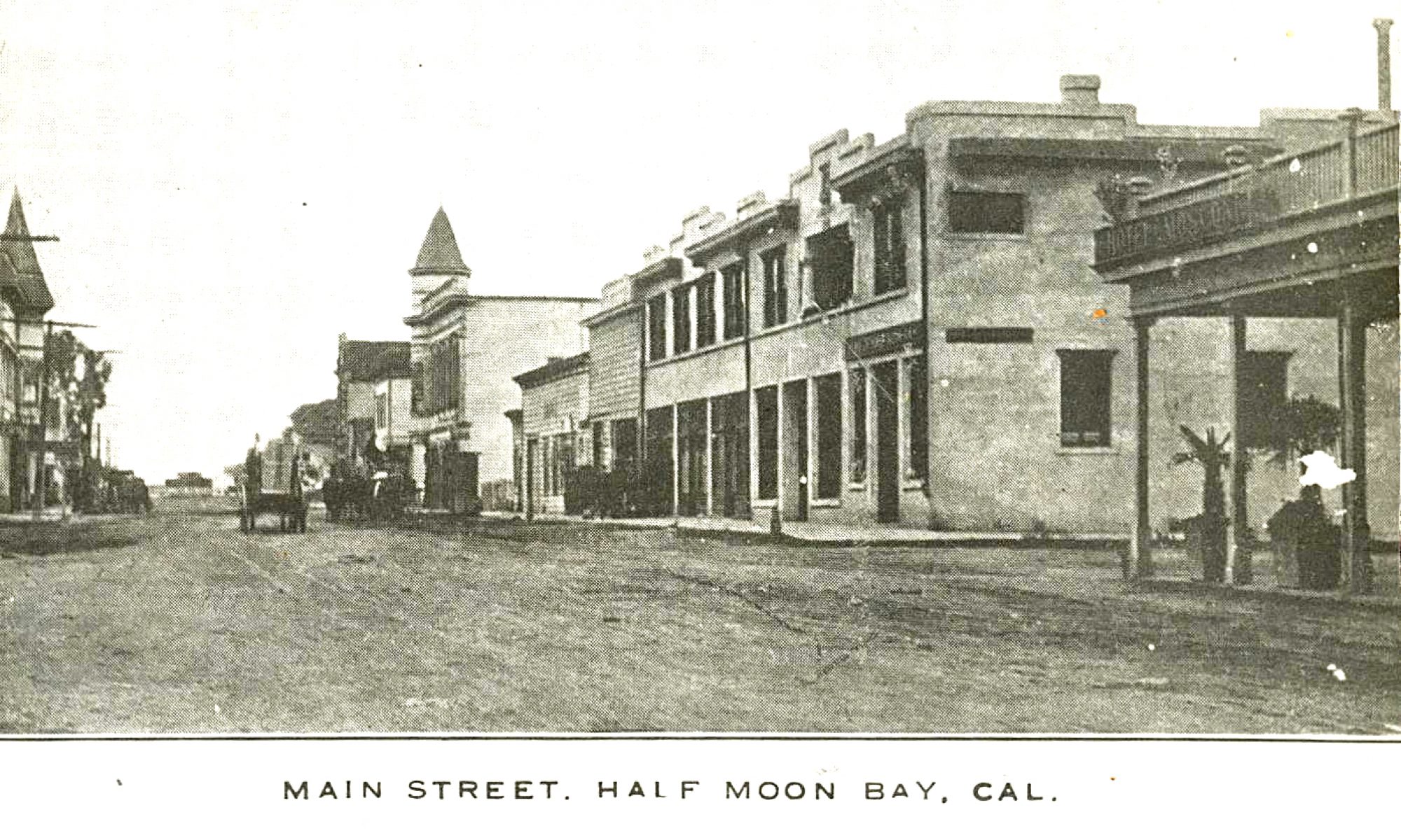
I’ve been researching that book that I sent you all the ads from. It is on Archive.org and is entitled, “Handbook and Directory of Santa Clara, San Benito, Santa Cruz, Monterey, and San Mateo Counties.” It was produced by Luther L. Paulson in 1875, part of series covering all of the Pacific coast, of which he apparently produced only four, covering most of the coastal or near-counties of California. The other three were produced in 1874 and 1876; one for Southern California, one for the northern counties of the Bay Area, and one for Alameda County.
They are essentially “Yellow Page” style books, that businesses could buy a full page advertisement in for $20, or a half page for $15, or a quarter page for $10. But, they were much more too. They all included a list of the post offices of the Pacific Coast. Also, each included what was purported to be a complete listing of every permanent resident of the respective counties they covered, with those people’s occupation and postal address.
For the county of San Mateo there are more then 40 pages, with about 65 people a page, over 2,500 people. Farmer, dairyman, laborer, trader, wagonmaker, barber, clerk, blacksmith, teamster, lumberman, machinist, engineer; they’re all represented. It’s a comprehensive look at who was where, and doing what, in the still raw county of San Mateo in 1875.
Even more fascinating are the local ads. Ads for stagelines, liveries, a millinery, druggist and chemist, attorneys, a butcher, saloons, hotels, a flouring mill, general merchandisers, saddle maker, physician and surgeon, and of course, undertakers are all proudly displayed. Many of these ads have high quality drawings or quite fancy layouts.
There are also short descriptions of several of the cities in San Mateo County, and there used to be maps of the covered counties in the book, but they, along with a few other pages, seem to be missing.
These four volumes seem to be the height of the publisher, Luther L. Lauson’s, career. I can find no mention of him, other then related to these books, anywhere else. The printing company he used, “Francis and Valentine Steam Press” was well known, and apparently the largest printer on the Pacific coast for many years. They specialized in doing jobs for those lacking their own presses, and have a full page ad for themselves in the book.
Unfortunately, on Christmas Day, 1893, a fire broke out in the block where their plant was located, as well most of the other printing companies and newspapers located in San Francisco at that time, and their many presses were destroyed. They never fully recovered, and another fire in the same building, five years later, forced them into bankruptcy. While Mr. Paulson’s endeavors may not have been a great financial success, they leave us with a fascinating view of the financial vibrancy of the early days of San Mateo County. Enjoy.
I’ve attached some drawings from the “Morning Call” and the “Call,” and part of the article about the fire, as the papers were not damaged severely by the fire, and were able to keep publishing.
I am sending the two Tunitas Ocean Shore Railway photos as jpegs. I hope they open alright. The one of the trestle missing it’s north end was from about 1938.
The photo of the Tunitas depot dates from the same time period. I recall during the late 1960s seeing the ruins of the depot after the fire. It was a great loss to me as a railroad fan. The photos are from my collection via Rudy Brandt. Rudy Brandt or Robert McFarland took the photos.
Hi, John. Thanks very much for the Tunitas Long Bridge and station
photos–which opened up fine. I remember the station and its loading
platform, but didn’t go down to take pictures or examine it more closely–I
had only a box camera during those Depression days and don’t think I had it
with me. I think the station had galvanized siding, or maybe just the roof.
As I drove by with my friend (who’d borrowed his brother’s Model A Ford )
on our way to Santa Cruz, all that remained of the trestle was on the South
side up to about the first x-shaped reinforcements between bents. I was
driving and had just gotten my driver’s license at age 16; this places the
year as 1939. Since the photo you sent dates to about 1938, this jibes
with my hunch that the trestle was being dismantled from the north end,
though
I don’t recall seeing any such activity or equipment as we went by. Angelo
Not too long ago I did a series of postings about the historical Coastside upgrades done on Highway 1, and Skyline Blvd., that I had extracted from a series of “Highways and Public Works” pamphlets I found at Archive.org. The one about the new highway and bridge in the Pescadero area in 1941, mentioned that the Tunitas Creek area upgrade and others were coming soon. World War II delayed all those projects. After hours of flipping through thousands of pages online I was able to find every article about the improvements from Davenport to Pacifica, except the Tunitas Creek section. I tried to locate the date of the Tunitas bridge’s construction online with websearches, hoping to better focus my eyestraining search, but had no luck, and finally gave up.
Well, a few days ago John Schmale sent me this great century old picture of the almost completed Tunitas Trestle of the Ocean Shore Railroad
and the nearby, nearly fifty year old, Long Bridge. My interest was rekindled and as I mentioned I visited Tunitas Beach a couple of days ago. I walked over the bridge
and discovered it hadn’t been built until 1962 and photographed the spraypainted stencil indicating so.
I also photographed the bridge from the north end that shows the 1962 span and the newer section to the south, constructed after the huge landslide in the winter of 1998. Lastly, in the canyon below I took this photograph of the old foundations of the Long Bridge’s last incarnation, built sometime after the one portrayed in John Schmale’s photo, and replaced by the 1962 span. It was located less then 50 feet west of the present span. (I think you have a picture of that incarnation, but I don’t)
With the date from the stencil, I returned to Archive.org and went through 1962’s pamphlets, carefully, page by page, until I found a small paragraph in the May-June issue that stated:
“South of Half Moon Bay on Sign Route 1 (Cabrillo Highway), work is under way on a $592,000 contract between .5 mile south of and .3 mile north of Tunitas Creek. The work includes construction of a new bridge across the Tunitas Creek and improving the approaches.”
Unfortunately, after extensive searching I think that is the best there is. By 1962 there were so many big projects going on in the Bay Area, that a half a million dollar project out on the coast just didn’t rate page space, I guess. The attached ScreenShot of Bay Area projects in 1962 illustrates why.
There was also an interesting item in one of the 1962 issues I’d like to share. It was the 50th anniversary of the pamphlet, in one form or another, and they had a memorial story. It included these two 1912 photos from Issue 1, Volume 1, of the “California Highway Bulletin,” depicting work on the El Camino Highway in San Mateo County. My, how things have changed.
Here are two of pics from Tunitas. The railroad trestle crossed over the county road on the north end. The county may have removed the overhead part of the trestle for safety reasons. Angelo,is this how you remember the structure? I guess only about four of the five railroad trestle abutments remain. The auto bridge in this photo does not match old photos of the main road bridge which is upstream from this one. It had about seven trusses and was quit long, hence “Long-bridge”. I believe that it was rebuilt in 1914 by the state. I have a photo showing the long wagon-auto bridge as well as some Ocean Shore Rail cars on the Railroad Trestle. I suspect that the “long-bridge” may have been replaced by the Highway-one bridge, which has again been replaced by the current bridge.
What do you think? The other pic is the Tunitas depot in about 1938. It burned in around 1967 or so. I will look for the newspaper clipping.
In David L. Durham’s “California’s Geographic Names: A Gazeteer of Historic and Modern Names of the State” there appears under Tunitas Creek (San Mateo) stream: “The (OS) railroad stop near the creek about 1910 was called Long Bridge for a structure built across the stream in 1869. (Browm P. 49.)” This coincides more with your findings that the the Long Bridge name originated from an early roadway and not with my view that it was that the OS had so named its 515 foot trestle, though the railroad must have appropriated the name for its own use as previously explained. I found the above by Googling: Long Bridge at Tunitas Glen/David L Durham. The reference to Brown is probably to Thomas P. Brown’s “Colorful California Names: Their History and Meaning.” Angelo
Elaine Teixeira’s Half Moon Bay High Class Reunion
Story by Elaine Teixeira
A Half Moon Bay High School reunion was held at Nick’s in Rockaway for graduates, spouses, and former members of the classes 1944-1956 on October 10. Pat Baldwin Weir and her committee have organized these reunions every 5 years for at least 20 years. This year, it was only three years since the last and it was one of the largest groups ever to attend. Pat is already planning the next reunion and deserves a big hand, along with her committee, for putting so much effort into making these events such a success.
Photos by Fred Cunha
Images of some of the attendees: Bev Cunha Ashcraft, Pedro Corral, Terri Santini, Bruno & Gwen Giusti, Norman Carter, Dorothy Gillie Bettencourt, Jack Bettencourt, Jerome Vallado and Lorraine Gabriellie Valladao, Donald Benson, & Virginia Frances.


 Elaine Teixeira’s Half Moon Bay High Class Reunion


