click here
Created by June Morrall
Email Larry Kaplan: [email protected]
You may recall my “Conversations with Larry Kaplan”
We went to Lincoln High School in San Francisco together. He drove there; I walked.
Here’s Larry: 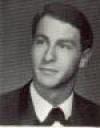 and here’s me:
Coincidentally, we both attended San Jose State and even more coincidentally we lived in the same apartment building at 555 South 8th Street. Back then, in the late 1960s and early 1970s, lots of students lived off campus, renting rooms in these wonderful old Victorian houses.
Our apartment building was boring architecturally and the cop fraternity was next door so we had to be on our best behavior.
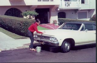
On weekends I drove home to San Francisco to see my folks in my 1966 Chevy Malibu, yellow with a black vinyl top.
Larry rode his ten speed home to see his parents in the City–or packed his wheels into the trunk of my roommate Sue’s car and traveled with her.
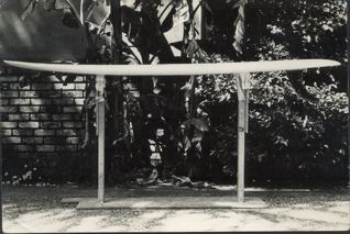
Later, when I moved to the Coastside, I encountered Larry waxing his surfboard at El Granada Beach. While there, Larry doodled some sketches in the notebook I was carrying.
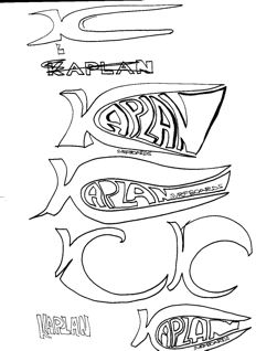
At the time he wanted to make surfboards and the doodlings were actually the beginning of a business that would broaden into expert yacht repair and much more.
Here’s a photo of an early Kaplan surfboard–handmade at our 555 So. 8th Street apartment building in San Jose.
Years passed, decades flew by–and I gave birth to my website called halfmoonbaymemories.com. I keep everything, so it was no surprise to find Larry Kaplan’s doodlings among all my stuff. I posted them, and one day, to my great surprise, Larry got in contact with me…which led to my posts called “Conversations with Larry Kaplan….”
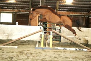
I learned that he was the owner of the Thoroughbred called Vegas, a horse that really flies. If you don’t remember, here’s Vegas:
Now it’s the Holidays, time to re-connect with old friends and what better place to meet than here at my website. It’s quiet here and we can talk.
Larry: The sailing shot
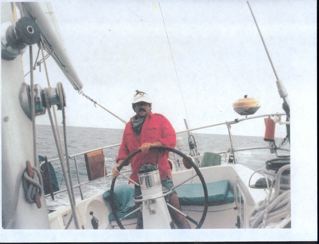 is of me at the helm of a 57′ Swan ketch. I was hired to take her from Oahu to San Diego. There were three of us aboard. We had five sails up the entire way and we hauled ass…got to San Diego in 16 days.(that’s fast). Expect the photos in the morning, please. I am SO proud of you and books. Do I get to purchase one?
June: You mean my new “Princeton-by-the-Sea book? You can come to my booksigning at Bay Book in Half Moon Bay on Friday, December 14 at 7 pm. Tell me about WANDA.
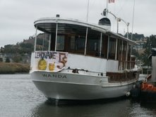
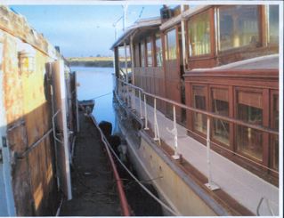
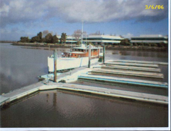
Larry: The photo of WANDA depicts her as a yacht; a WHOLE yacht.
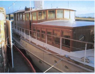
The ones you recv’d with the Tug photos
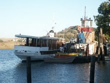
showed WANDA from her stern and I wanted you to see just how majestic she really is. She is due for complete restoration and those logistics are what are currently being bantered about. In the meantime, when I go to Petaloooooooooooma, I play with the Tugboat and I check on the wellbeing of WANDA.
June: How did you and Wanda become acquainted?
Larry: I needed a place to park one of my client’s yachts for a year or so, and she is side tied to my friend’s Tugboat. Her name is WANDA; she is 90′ long and she was built in 1922. My clients are in Canada and I get to play with WANDA at will. I do. WANDA is my haven, I say, HAVEN away from home. There is a funny sign on WANDA’S stern about lemonade.
June: What else?
Larry: A dear friend of mine; we literally grew up together…he went to Lowellllll while you and I went to the right place; anyway, he bought a 65′ Tugboat that is sixty years old. He does not know boats. I do. His Tug is parked on the Petaluma River VERY near downtown Petaluma and the Riverfront re-construction effort that is re-vitalizing the entire downtown of Petalooooma.
(Photo: The WANDA in full)
June: Well, Lar, you look like you’re aging well.
Larry: Getting old as gracefully and as fast as I can….(I DO need to trim my moustache…there. Perfect!)
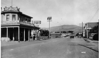
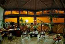
(Photo: HMB Hotel, Dominics…and most recently the San Benito House [which has been sold in 2007] at the corner of Mill & Main Streets.)
From the Half Moon Bay Review, 1960s
“Domenic’s Place Sale Negotiations Now Under Way”
“Negotiations for the sale of Domenic’s Place in Half Moon Bay are now under way, according to Domenic Dagani who says that Michael deValera Murphy of San Mateo plans to purchase the business.
“The establishment located at the corner of Mill street and Main street, has been operated since June 27, 1935, when Dominic purchased it from Mrs. Abramo Luchessi of Purisima. It was previously known as the H.M.B. Hotel.
“It was indicated that if license transfer and financial arrangements are completed, the new owner will take possession by May 15, it was said.
“Dagani, who was born in Italy and spent part of his life in Switzerland before coming to the U.S. in 1921, came to the Coastside and worked at Dan’s Place in Moss Beach from 1924 to 1934. For a time he worked with the late Charlie Carlini. He says he has made “no plans” as yet for his future activities.”
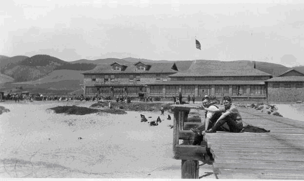
(Photo: El Granada, 1970s)
From the “Half Moon Bay Review,” 1960s
“Twenty two-year old Monterey Pines were planted in open spaces of The Alameda parkway in El Granada last Saturday, as the start of long range program of parkway beautification sponsored by the Granada Garden Group.
“The tree planting is being carried out in cooperation with the County Parks and Recreation Division, according to Sam Leedom of the garden organization.
“The Monterey Pines were obtained through the courtesy of Daniel Willis, chief of the County Park Department, when the Garden Group found the State Division of Forestry did not have the stock available, Leedom said.
“The planting in the Alameda parkway is designed to carry out the original plan of having that thoroughfare lined with Monterey Pines as it now is between Isabella and Portola and from Balboa down to Alhambra Street.
Continue reading “1960s: 20 Monterey Pines Planted In El Granada”
To see original story, click here
Story by Ken Freeze–Check-Six.com (with special thanks to John Vonderlin for sending it to me)
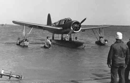
Kingfisher Crash off San Francisco
May 9, 1943
By Ken Freeze
Coast Guard Air Station San Francisco during World War II
Flight operations from the air station consisted mainly of anti-submarine patrols and search and rescue missions using a mix of aircraft that included Hall PH-3, Douglas RD-4, Consolidated PBY-5, some Grumman J4F-1s, and six Vought OS2U-2 Kingfishers from the Navy.
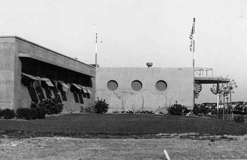 (Photo: The Barracks at Coast Guard Air Station San Francisco in 1943)
By 1943, seeing Navy personnel working along side Coasties was a common sight at the air station. So on May 9th 1943, when Coast Guard Radioman Henry Kind climbed aboard Navy OS2U-2 Kingfisher No. 2270 along with Navy pilot LTjg Dale C. Burroughs, it was just another routine anti-submarine patrol along the California coast. However, this patrol was to end very differently.
The Last Flight of Kingfisher #2270
“We left that afternoon on a coastal patrol carrying two 100 pound bombs,” said Kind. Kind had flown a similar patrol just the day before and had flown with LTjg Burroughs a number of times over the previous months.
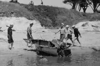
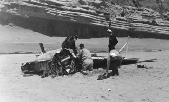
The patrol that day was uneventful and, after four hours in the air, Burroughs and Kind were just minutes from landing back at Coast Guard Air Station San Francisco when the Kingfisher approached San Gregorio Beach, on the coast about 30 miles south of the air station.
Kind remembers what happened next very well. “LTjg Burroughs called back to me and asked if I had my seat belt fastened,” said Kind. “LT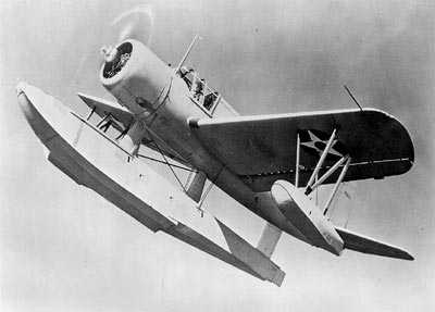 Burroughs said his wasn’t, but he knew what he was about to do and I didn’t. He then put the plane into a dive then climbed to the left toward the ocean. The plane started to feel like someone was shaking it.”
The next thing Kind knew was he was underwater. “I fought my way to the surface,” said Kind. “My seat had been completely ripped from the plane and there was a hole in the side of the plane. That seat breaking loose the way it did probably saved my life.”
Unbeknownst to Kind, LTjg Burroughs had put the Kingfisher into a whip stall, a maneuver that is difficult to recover from at high altitude even for an experienced pilot, and one that at low altitude is often deadly. In this case, 22-year-old LTjg Burroughs, had paid the ultimate price for his stunt.
“I never saw the pilot after the crash,” Kind said. “I tried diving for him but I was wearing an inflated ‘Mae West’ life vest and both my legs were injured.”
Alive – But Not Safe
While Kind may have survived the crash, he wasn’t safe yet. He was badly injured, floating in the chilly waters of the Northern California Coast and nearly a quarter mile from shore.
Meanwhile, on the beach a group of students from Stanford University had witnessed the accident.
“It was Sunday, and a bunch of us Stanford kids were out at the beach,” said Robert W. Brown. “We saw this plane come down the beach, flying very low. At the north end of the beach there’s this promontory that sticks out. The plane came up to it and climbed up while banking. It then lost air speed and crashed into the water three or four hundred yards off the beach.”
“I had done a lot of ocean swimming off the Atlantic coast so swimming in the ocean didn’t bother me,” said Brown. “But the water was very cold and I didn’t want to swim out by myself.” Brown, who played shortstop for the varsity baseball team, asked another student, Robert McClean, to swim out with him.
Brown and McClean entered the water and made their way through the rough surf. “It took us quite a while to get out through the surf and to the plane,” said Brown. “We could see the one person floating in the water. He wasn’t moving so we knew he needed help. Once we got to him we towed him back in. It took us about 45 minute to an hour. We never did see any sign of the pilot.”
Soon another Navy plane was on the scene and dropped a rubber raft near the remnants of the Kingfisher. Later, additional Coast Guard personnel from San Francisco arrived on scene with a surfboat. Three of these Coasties suffered minor cuts and bruises when their boat overturned in the surf in their first attempt to reach the plane.
Once Kind was on the beach, he was taken by Army ambulance to a nearby Army aid station. From there he was taken to the Public Health Service Hospital in San Francisco. “I was in the hospital for a month,” Kind said. “My left thumb was badly fractured. Both legs were badly sprained and I had lots of cuts and bruises all over. I also lost all feeling in my left leg. It was all numb from the knee down. They had me wrapped up like a mummy.”
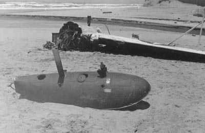
The next day, most of the wreckage of the Kingfisher had washed up on San Gregorio Beach. Crews tried to salvage as much of the wreckage as possible and also worked to recover the two bombs that the plane had been carrying. The body of LTjg Burroughs washed up on a beach nearby several days later.
Epilogue
After his month in the hospital, Kind spent another month as an out patient. But by July 1943, Kind was back at the Coast Guard Air Station flying again. 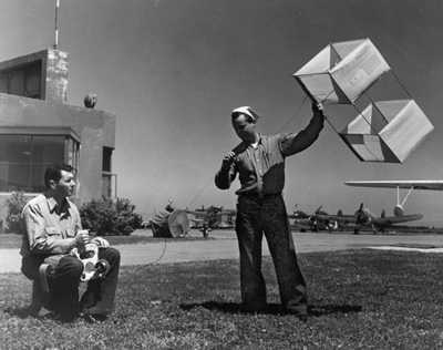 (Photo: Radioman Henry Kind on the left testing an emergency transmitter.)
Click here to view pages from his log book that deal with the crash.
Page 1 Page 2
Kind eventually left the Coast Guard and joined the San Francisco Police Department. He is now retired and living in Utah.
Radioman Henry Kind on the left testing an emergency transmitter.
Coast Guard Silver Lifesaving Medal
As for Brown, he finished up his studies at Stanford and enlisted in the Navy, being called to duty in July 1943. A year had passed and while waiting to go to medical school he was assigned to a local Naval Hospital as a corpsman.
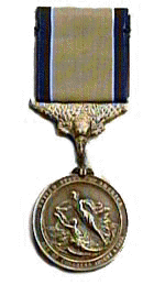 (Image: Coast Guard Silver Lifesaving Medal)
“One day the Captain called me in and presented me with a medal,” he said. “I heard him say ‘lifesaving medal’ so at first I thought is was a Carnegie Lifesaving Medal. It was only later that I found out that it was a Coast Guard Silver Lifesaving Medal.”
“I never saw Bob McClean again after that day,” said Brown. “I’m not sure what happened to him but I guess he also got a medal.”
Brown eventually made it to the Tulane University School of Medicine where he graduated as an M.D. in 1950.
Over the next 50 years, Brown had a full life to say the least. As a pro baseball player, fans packed the stadiums and cheered for him during four World Series championships as he stepped to the plate for the New York Yankees. He also saw the frontlines during the Korean War where he served as a doctor with the U.S. Army.
Then for 25 years, Brown dedicated his life to the practice of cardiology in Fort Worth, Texas before leaving for New York to be president of the American Baseball League.
Today, Brown has returned to Fort Worth where he enjoys retirement with his wife Sara.
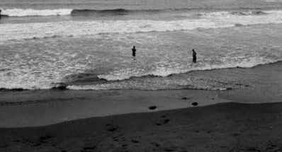
The Crash Site Today
San Gregorio Beach is now a State Beach. With a driftwood-strewn estuary, wide sandy beach and grassy bluffs along the coast, it is still a favorite place for many to spend a day. As people walk along the sand there is no evidence of the events on that spring day 60 years ago when, for just a moment, an error in judgment cost the life of one man, and nearly the life of another.
Click here
[Very special thanks to John Vonderlin for sending this to me. Email John: [email protected]
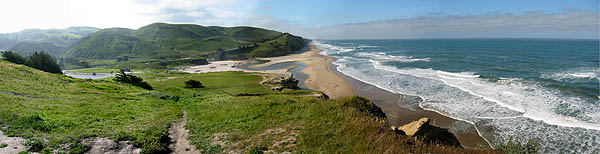
New Sonar Data Helps Explain Why ‘Mavericks’ Waves
are Among Nation’s Largest
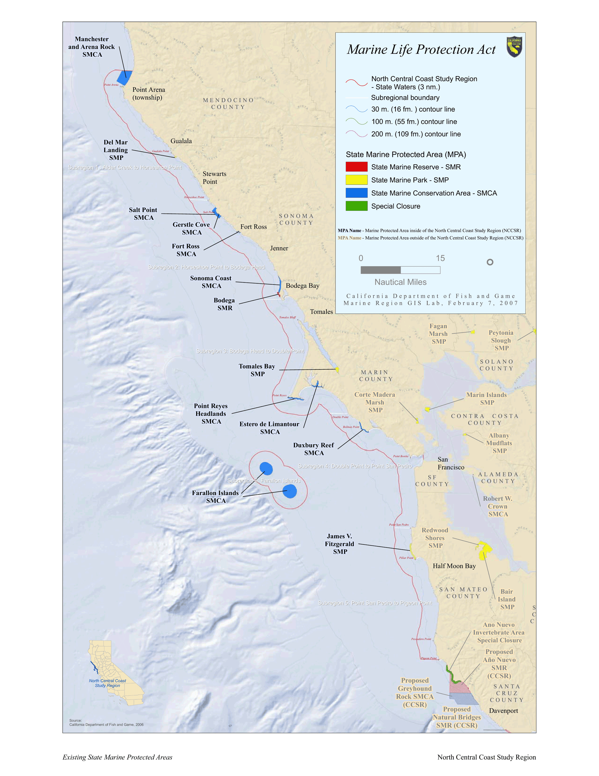 This map (click image for larger view) shows the geographic range of the north-central coast study region for the current phase of the Marine Life Protection Act implementation process. Seafloor mapping data is being collected throughout this entire area to provide habitat distribution information.
 This is a regional map (click image for larger view) showing National Marine Sanctuary boundaries, Bay Area faults, and the location of the data collected at Mavericks.
Over the last decade, the Mavericks surf break has captured international attention. An interesting question is, “Why do such big waves break here?”
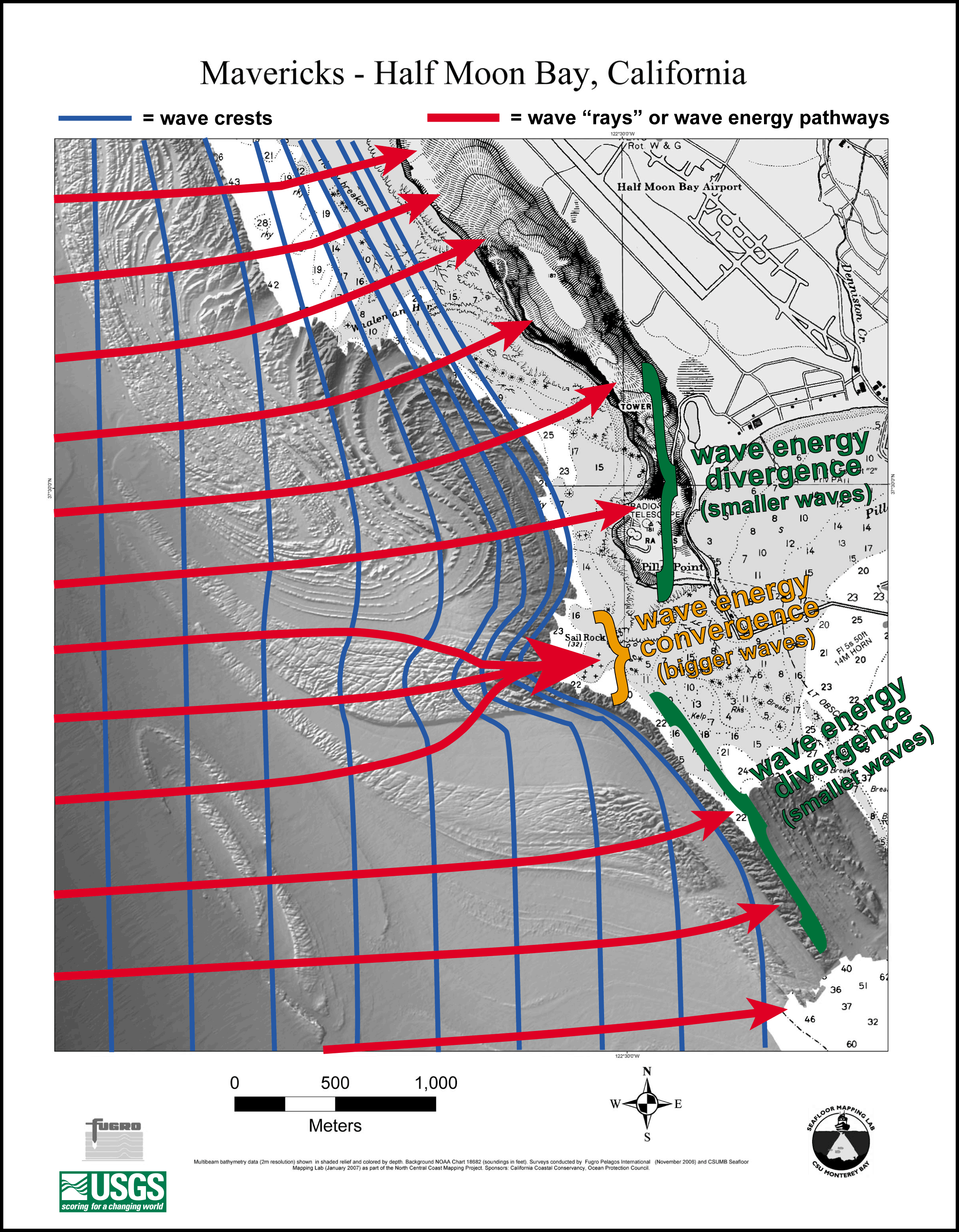 This is a map of shaded bathymetry with wave lines on it. The blue lines show hypothetical large wave crests propagating in to shore from the west. As the waves move into shallow water, they begin to interact with the seafloor (“shoal”) and their crests slowly bend to try to maintain their roughly parallel orientation to the bottom contours. The more the waves interact with the seafloor, the more they slow down and bunch up. Wave “rays”, or the pathways of wave energy, move perpendicular to the wave crests. In areas where the wave rays, and hence wave energy, diverges, the wave height decreases. Conversely, in areas where the wave rays, and hence wave energy, converges, the wave height increases. Due to the steep topography of the bedrock reef at Mavericks, the wave energy rapidly converges and the wave height rapidly increases, creating a huge wave compared to the adjacent areas.
The dominant wave direction off the central coast of California during most of the year is from the northwest. These waves propagate over the much gentler topography to the northwest of Sail Rock and are generally too small to shoal and break at Mavericks. Sometimes during the winter months, however, strong North Pacific storms generate large, long-period waves from more westerly directions that shoal and break over the bedrock reef just to the east of Sail Rock. The abrupt topography of the bedrock reef causes wave energy to converge over the reef, causing the wave to rapidly slow down, shorten in length and substantially increase in height relative to the areas just to the north and south of the east-west trending reef. This interaction of the geology and oceanography is what makes the wave at Mavericks so spectacular compared to many other locations along central California.
Mavericks flythrough animation (mpg, 10 MB)
This fly-through begins approximately ½ mile offshore from Pillar Point north of Half Moon Bay. The area we are looking at in detail is a shallow nearshore reef in the vicinity of the San Gregorio fault, a major active fault within the San Andreas fault system. Motion on the fault zone has uplifted and deformed the rocks in the area near Mavericks into the S and J shaped folds we see on the seafloor.
The 3-D image is color-coded by depth: the blue and green areas are deeper than the areas in yellow and red. You can see how rugged the sea floor is in this area with lots of ridges, valleys, chasms, and pinnacles.
The new data indicates that Mavericks is above a portion of the rocky reef that is shallower than the surrounding rock. As a wave front approaches the shoreline and progressively enters shallow water, it becomes compressed and grows taller. The ridge promontory also has the effect of focusing wave energy and the wave height rapidly increases, creating a huge wave compared to adjacent areas. About here (the highest red we see), the wave becomes unstable and breaks. In fact, the data collection stopped here because the rough sea conditions made it too dangerous for the scientists to operate their boat!
Although interesting for explaining the mystery of Mavericks, scientists and resource managers will be using this data to identify hazards to navigation, classify different habitat types, locate biological hot spots, and study the San Gregorio fault.
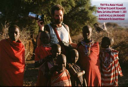
This is where our adventure-seeking Coastside photographer Michael Powers was–stopping to visit with kids from a Masai tribe in eastern Kenya] on his way to climb Mt. Kilimanjaro in Tanzania.
Few people know that long ago I put on my carpenter clothes, brought my hammer down to Miramar Beach and helped nail some redwood shingles onto Michael’s famous geodesic dome. Incidentally, Michael told me, “I’m still looking for a creative spirit with fire in the belly to share our new studio… if you know of someone who might fit here, have them call me asap! 650- 726-2748.”
If you think you’re a candidate, call Michael.
When I first landed on the Coastside, and became intrigued with local history, I met with Louie Miguel, whose father, Joseph, was one of the masterminds behind the spectacular Palace Miramar Hotel. Louie offered good background info and also talked about the US military taking over his father’s buildings during WWII.
[The military moved into many of the Coastside’s public buildings, and most certainly, those located on the beach side of the highway, as the Palace was.]
Below: To visit the âCalifornia State Militaryâ? website, click here
Camp Miramar
Story by Command Sergeant Major (CA) Dan Sebby
The former Camp Miramar was established on 21 April 1943 when the U.S. Army entered into leases with several land owners in order to provide for a camp to house infantry units assigned to the Western Defense Command. The 1 June 1943 edition of the Station List of the Army of the United States, issued by the Adjutant General of the U.S. Army, stated that a single rifle company, Company G of the 125th Infantry Regiment, was present at Camp Miramar.
At the time of acquisition, there were two major buildings that the U.S. Army took control of. The first was the Miramar School, a small elementary school that served the local faming community and located on the eastern parcel, between State Highway 1 and Valencia Street. The other major building was the Palace Miramar Hotel and Resort, a large redwood-shingled building located on the beach in the western parcel of the Site.
In a letter to the Adjutant General, U.S. Army; dated 23 January 1944, the Western Defense Command identified the Site as vacant and excess to its needs. On 11 May 1944, Office of the Chief of Engineers at the War Department approved a request from the Bureau of Yards and Docks of the Navy Department for the six of the barracks and one on the latrine buildings. This transfer of the buildings to the Point Montera Anti-Aircraft Training Center was made without the U.S. Navy becoming responsible for restoration the land on which the buildings were situated.
From September until December 1944, the U.S. Army terminated its leases for the Site. A 1946 aerial photograph does not show any of the CCC buildings remaining. On 6 May 1952, the U.S. Army terminated its permits for water and sewer lines that ran along State Highway 1.
| Facility Name or Function | Quantity | Building Type | Size |
| Mess Hall | 2 | CCC design | 20â²x130â² |
| Barracks | 3 | CCC design | 20â²x130â² |
| Barracks | 2 | CCC design | 20â²x120â² |
| Barracks | 3 | CCC design | 20â²x100â² |
| Officers Quarters | 1 | CCC design | 20â²x70â² |
| Storage | 1 | CCC design | 20â²x40â² |
| Storage | 1 | CCC design | 20â²x30â² |
| Latrine | 1 | CCC design | 20â²x45â² |
| Latrine | 1 | CCC design | 20â²x55â² |
| Miramar School | 1 | Unlnown | 3,500 square feet |
| Palace Miramar | 1 | Wood Frame |
Sources: NARA Records, College Park, Maryland
I got this piece of Congressman Ron Paul political art via the human links of family & friends: Burt and I enjoyed Thanksgiving dinner at my cousin Gabriele Korn’s home “over the hill”, and with a sparkle in her eye, she said she had something for me. She handed me this postcard sized artist’s rendering of Congressman Paul’s likeness–produced by the locally based “Skyline Movement.” And how did she get it? From her chiropractor, Mark Reis, a great guy,who is also my chiropractor (but fortunately I haven’t had to see him recently.)
It’s not unusual to see similar political mailings but this one was not a photograph. This is a piece of genuine art that somebody labored over.
For those who don’t know anything about Congressman Paul, he’s running for President in the Republican primaries–and has stunned conventional political observers with the groundswell of support from people excited by Dr. Paul’s anti-war, pro-Constitution stance.

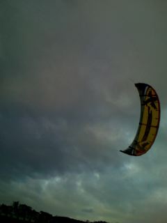
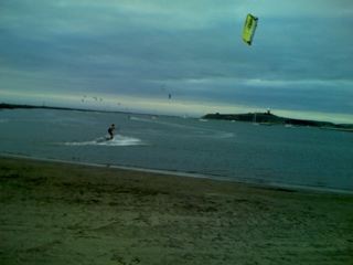
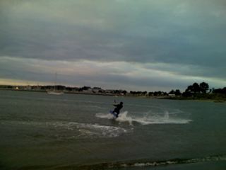
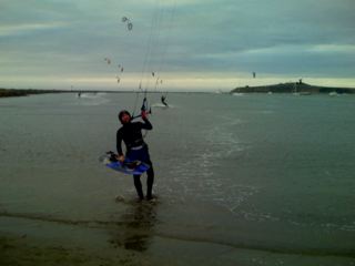
Only on rare days like today– when the gusty winds are blowing sideways, and the surly waves are whipping up a froth–do the kite surfers come to our shores….and they were here today where I encountered Luis, a Brazilian filmmaker.
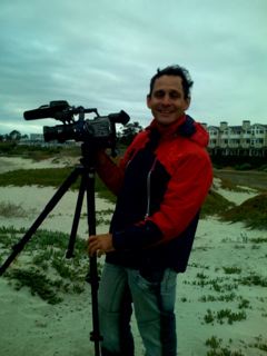
(Photo: Brazilian filmmaker Luis…The pix below are mine and I wish Luis would send me his!)
Luis was making a film about the kite-surfers–some of them his friends. These were not ordinary kite-surfers–they were professionals athletes being swept by the winds 30 feet into the air, making elegant sharp turns (like professional ice skaters) in the surf. At one point there were at least a dozen of these giant, colorful kites in the air.